Cartograaf:Jacob Kuyper (1821-1908)


Terug naar Historische kaarten
Historische kaarten
Impressum 1866
![]() 1866 - Gemeente Baexem
1866 - Gemeente Baexem
Cartograaf Jacob Kuyper (1821-1908)
Kaart afkomstig uit Gemeente Atlas Nederland 1868 aanwezig in atlas1868Impressum 1866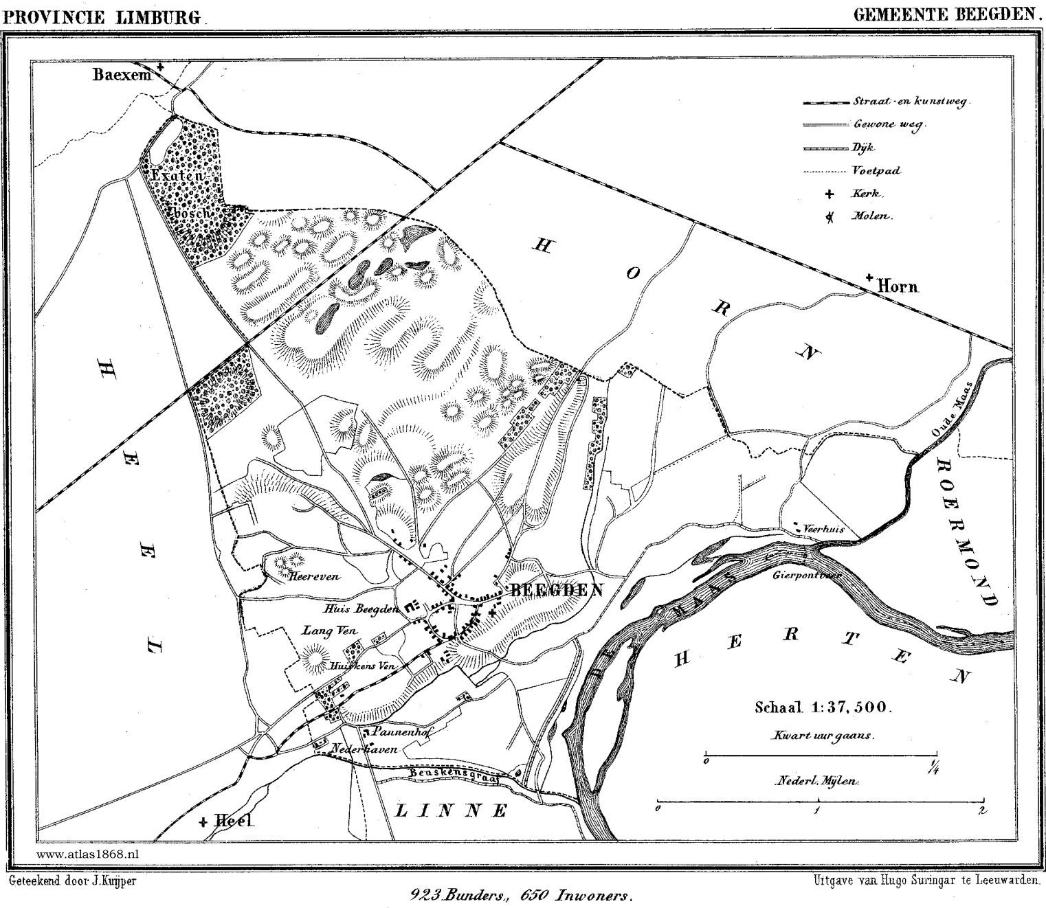
![]() 1866 - Gemeente Beegden
1866 - Gemeente Beegden
Cartograaf Jacob Kuyper (1821-1908)
Kaart afkomstig uit Gemeente Atlas Nederland 1868 aanwezig in atlas1868Impressum 1866
![]() 1866 - Gemeente Heel en Panheel
1866 - Gemeente Heel en Panheel
Cartograaf Jacob Kuyper (1821-1908)
Kaart afkomstig uit Gemeente Atlas Nederland 1868 aanwezig in atlas1868Impressum 1866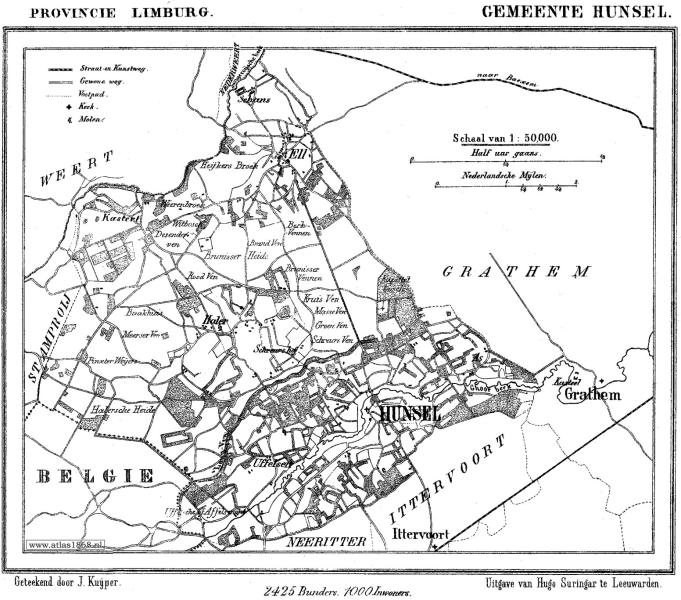
![]() 1866 - Gemeente Hunsel
1866 - Gemeente Hunsel
Cartograaf Jacob Kuyper (1821-1908)
Kaart afkomstig uit Gemeente Atlas Nederland 1868 aanwezig in atlas1868Impressum 1866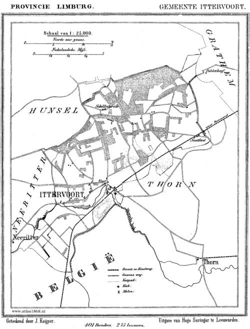
![]() 1866 - Gemeente Ittervoort
1866 - Gemeente Ittervoort
Cartograaf Jacob Kuyper (1821-1908)
Kaart afkomstig uit Gemeente Atlas Nederland 1868 aanwezig in atlas1868Impressum 1866
![]() 1866 - Gemeente Neeritter
1866 - Gemeente Neeritter
Cartograaf Jacob Kuyper (1821-1908)
Kaart afkomstig van < Gemeente Atlas Nederland 1868>Impressum 1866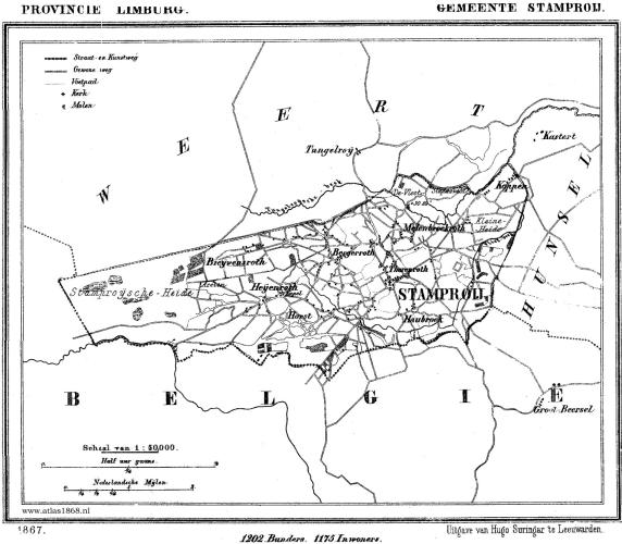
![]() 1866 - Gemeente Stramproy
1866 - Gemeente Stramproy
Cartograaf Jacob Kuyper (1821-1908)
Kaart afkomstig uit Gemeente Atlas Nederland 1868 aanwezig in atlas1868Impressum 1866
![]() 1866 - Gemeente Wessem
1866 - Gemeente Wessem
Cartograaf Jacob Kuyper (1821-1908)
Kaart afkomstig uit Gemeente Atlas Nederland 1868 aanwezig in atlas1868Impressum 1867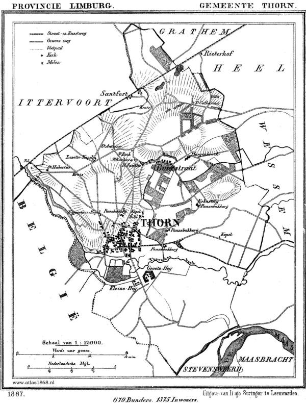
![]() 1867 - Gemeente Thorn
1867 - Gemeente Thorn
Cartograaf Jacob Kuyper (1821-1908)
Kaart afkomstig uit Gemeente Atlas Nederland 1868 aanwezig in atlas1868Impressum 1867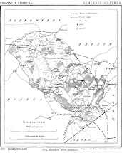
![]() 1867 - Grathem
1867 - Grathem
Cartograaf Jacob Kuyper (1821-1908)
Kaart afkomstig uit Gemeente Atlas Nederland 1868 aanwezig in atlas1868