Kaart:Plaats:Stramproy:1764-1771:1
|kaart=Plaats:Stramproy:1764-1771:1
|impressum=1771
|impressumeind=1778
|afbeelding=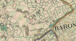 |afbeelding_groot=
 |cartograaf=Joseph-Jean-François graaf de Ferraris (1726-1814)
|archiefstuk=http://mapire.eu/en/map/belgium/?layers=osm%2C87&bbox=635077.6171167436%2C6654238.531945456%2C639663.8388138543%2C6656658.241622109
|archief_url=http://mapire.eu
|archief=Mapire
|type=iframe
}}Terug naar Historische kaarten
|cartograaf=Joseph-Jean-François graaf de Ferraris (1726-1814)
|archiefstuk=http://mapire.eu/en/map/belgium/?layers=osm%2C87&bbox=635077.6171167436%2C6654238.531945456%2C639663.8388138543%2C6656658.241622109
|archief_url=http://mapire.eu
|archief=Mapire
|type=iframe
}}Terug naar Historische kaarten
Impressum 1764-1771 (vertaald)Cartograaf Österreichische Niederlande (1764–1771) - First Military Survey
Kaart afkomstig van Mapire