Plaats:Baexem:1861:1: verschil tussen versies
Nieuwe pagina aangemaakt met '{{sys:kaart:semantic |kaart={{PAGENAME}} |impressum=1861 |afbeelding_groot=https://lh3.googleusercontent.com/d-qb3UjyLO8soEKXXZRhc7AU7h3ynadb-6UiGJ3UrTD16BqJsTBkjD8...' |
Geen bewerkingssamenvatting |
||
| (14 tussenliggende versies door dezelfde gebruiker niet weergegeven) | |||
| Regel 2: | Regel 2: | ||
|kaart={{PAGENAME}} | |kaart={{PAGENAME}} | ||
|impressum=1861 | |impressum=1861 | ||
| | |afbeelding=https://mdsr.ghklandvanthorn.nl/imsr/i/I7ZmJ2bt.jpg | ||
|afbeelding_groot=I7ZmJ2b.jpg | |||
|cartograaf=Topographic and military map of the Kingdom of the Netherlands (1861) | |cartograaf=Topographic and military map of the Kingdom of the Netherlands (1861) | ||
|archiefstuk=https://mapire.eu/en/map/netherlands-1861/?bbox=651130.6879626447%2C6658616.034128094%2C660303.1313568659%2C6661960.154115571&map-list=1&layers=19 | |archiefstuk=https://mapire.eu/en/map/netherlands-1861/?bbox=651130.6879626447%2C6658616.034128094%2C660303.1313568659%2C6661960.154115571&map-list=1&layers=19 | ||
| Regel 8: | Regel 9: | ||
|archief=Mapire | |archief=Mapire | ||
|type=iframe | |type=iframe | ||
}}{{sys:terug|pagina=Historische kaarten}}{{sys:kaart:overzicht|kaart={{ | |direct=true | ||
}}{{sys:terug|pagina=Historische kaarten}} | |||
{{sys:kaart:overzicht|kaart={{sys:titeldeel|veld=1|segment=4}}}} | |||
[[Categorie:Kaart:{{sys:titeldeel|veld=0|segment=2}}]] | [[Categorie:Kaart:{{sys:titeldeel|veld=0|segment=2}}]] | ||
[[Categorie:Kaart:Monument:Baexem:Johannnes de Doper]] | [[Categorie:Kaart:Monument:Baexem:Johannnes de Doper]] | ||
[[Categorie:Kaart:Monument:Baexem:Huize de Brias]] | |||
[[Categorie:Kaart:Monument:Baexem:Kasteel Baexem]] | [[Categorie:Kaart:Monument:Baexem:Kasteel Baexem]] | ||
[[Categorie:Kaart:Monument:Baexem:Kasteel Exaten]] | [[Categorie:Kaart:Monument:Baexem:Kasteel Exaten]] | ||
Huidige versie van 18 okt 2025 om 12:37
Terug naar Historische kaarten
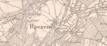
Impressum 1861 (vertaald)Cartograaf Topographic and military map of the Kingdom of the Netherlands (1861)
Kaart afkomstig van Mapire